Showing posts with label Godot. Show all posts

Monday, May 5, 2025

PolyMap & MinOne - MinOne gets Log-Odds (#5)

Improving Minone and PolyMap with Log-Odds

I have recently upgraded Minone and the PolyMap mapping system, focusing particularly on enhancing our use of a Single Ultrasonic Sensor. While the sensor hardware remains unchanged, introducing the concept of "log-odds" has significantly reduced the impact of noise and false readings, making our maps clearer and more accurate.

What are Log-Odds? (Explained Simply)

Imagine you're guessing whether it will rain today. You might say there's a 50/50 chance—that's "even odds." Now, suppose new clouds roll in, and your chances become "likely" rain, maybe 75%. Each time you get new information, your confidence about rain happening or not happening changes.

Log-odds is just a special way of keeping track of these changing guesses. It turns probability—the chance something is true—into a number that's easier to update quickly. Positive log-odds numbers mean "more likely," negative log-odds numbers mean "less likely," and zero means completely uncertain.

Occupancy Grids - Binary vs Log-Odds

Applying Log-Odds in PolyMap's Occupancy Grids

In mapping, especially with sensors like the ultrasonic sensor used in Minone, each measurement tells us something about whether space is empty or occupied. However, sensors aren't perfect; sometimes they say there's something there when there isn't (false positive) or fail to detect something that really is there (false negative).

Using log-odds, The system doesn't just accept each measurement blindly. Instead, it builds confidence over multiple readings. Every time the ultrasonic sensor scans an area:

  • A positive reading increases the log-odds, suggesting the area might be occupied.

  • A negative reading decreases the log-odds, suggesting the area is likely empty.

Over time, genuine obstacles build a strong positive score, clearly marking them as occupied on our map. Meanwhile, random noise, causing occasional false readings, doesn't build enough consistent evidence, so these points eventually fade away, staying neutral or negative.

This approach makes the PolyMap occupancy grids more reliable and accurate, greatly improving how robots navigate and interact with their surroundings.

A Deeper Look into the Math of Log-Odds

Log-odds translate probabilities from their natural scale (0 to 1) into a 'logarithmic space,' which makes it easier and computationally more efficient to combine multiple pieces of evidence. In probability space, values close to 0 or 1 become increasingly difficult to update because small incremental changes can have disproportionate effects. By shifting to log-space, updating becomes straightforward additions and subtractions, maintaining precision across multiple sensor updates.

When updating log-odds:

  • Positive evidence: If our sensor indicates an obstacle, we add a fixed positive log-odds increment, quickly shifting the belief towards occupied.

  • Negative evidence: If the sensor suggests no obstacle, we subtract a smaller fixed increment, slowly shifting back towards uncertainty or free space.

To prevent numerical instability, clamps are applied to the log-odds values. These clamps set upper and lower bounds, ensuring values remain within practical limits, preventing overruns that could result in overly confident (extreme) occupancy or vacancy assertions.

This additive and controlled adjustment property allows for quick, stable, and efficient updating, even with multiple sensor readings, greatly enhancing computational efficiency and clarity in interpreting sensor data.

Practical Results from PolyMap

Since implementing log-odds in PolyMap, there are substantial improvements:

  • Reduction of False Negatives: Previously, true obstacles were sometimes overlooked due to sensor noise and rapid changes in sensor readings. By quickly reinforcing log-odds with positive detections and slowly decreasing with negative readings, our system now reliably maintains the presence of real obstacles, significantly reducing false negatives.

  • Clearer Obstacle Identification: True obstacles are now distinctly recognized after several confirmations, making navigation decisions safer and more confident.

These practical outcomes directly enhance robot efficiency, reducing navigation errors and improving path planning capabilities.

Future Improvements and Considerations

Moving forward, I will be exploring additional enhancements to further refine occupancy grid accuracy:

A key challenge is tackling the ultrasonic sensor's tendency to miss obstacles when pulses reflect at oblique angles, effectively making these obstacles invisible. This issue arises because the sensor’s sound pulse can deflect away, failing to return the echo needed for detection. To address this, I am considering several options:

  • Sensor Fusion: Integrating data from multiple sensor types, such as infrared, alongside our ultrasonic sensor to build an even more accurate picture.

  • Multi-Angle Sensors: Using multiple ultrasonic sensors at different angles to ensure obstacles are detected from various perspectives.

  • Adaptive Orientation: Dynamically adjusting the sensor's orientation or positioning to better capture reflections from challenging angles.

  • Enhanced Signal Processing: Implementing advanced signal analysis techniques to better distinguish weak echoes or indirect reflections.

I believe these improvements will further strengthen PolyMap's reliability, making the robot even smarter and more autonomous. 

Sunday, April 27, 2025

PolyMap & Minone: First Test Results (#4)

Simple SLAM Robot: Initial Tests with PolyMap and Minone

Both the PolyMap mapping platform and the Minone robot have reached a level of functionality sufficient for their initial tests together. The early results are exciting, though clearly revealing room for improvement—exactly as anticipated!

Here's a video capturing these very first tests. Having this visual documentation will greatly help us track the robot's progression as we refine and improve the SLAM capabilities.

Overview of the First SLAM Tests

These initial tests show how well the mapping system, PolyMap, works together with Minone, a very minimal robot platform that is built around an ESP32 microcontroller. Minone, equipped with only a single ultrasonic sensor, navigated a confined hallway environment. All communication between the robot and the mapping software was successfully managed via MQTT, demonstrating effective real-time integration.

Minone, alone in the hallway.


In this test setup, Minone was in a hallway out of my vision. My phone was recording its movement. I sat in an adjacent room behind the door and was instructing the robot through the visualization. Commands were sent using MQTT to the robot and telemetry and map data was returned as previously discussed. In this test, I did have the reassurance that it was working, as I could hear the motor movement down the hallway.

Mapping Process and Key Observations

The PolyMap visualization provided live feedback during the tests with telemetry and maps. On the map you can see:

  • Robot position was clearly indicated in orange.

  • Obstacles detected by the ultrasonic sensor appeared in red.

  • Unexplored areas remained marked in black.

  • Telemetry shows the Pose (X, Y, Θ) and state: Manual

PolyMap Viz April 2025 (Totally Not Evil Robot Army)

The visualization effectively demonstrated the system's ability to build a cohesive map from successive sensor readings. However, the tests quickly highlighted significant limitations associated with relying on a single ultrasonic sensor:

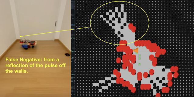
  • False negatives: The sensor occasionally failed to detect obstacles, particularly when encountering oblique angles. The pulsed ultrasonic signal reflects off the surface and does not return to the sensor, the device times out waiting, and returns a long distance (in this case greater than 170cm)

  • False positives: There were numerous instances of the sensor incorrectly registering obstacles due to noise and sensor inaccuracies. This could be due to echos, but otherwise indeterminate (for me at this time).

Minone, False Neg due to Reflection in corner.

These limitations underscore a common challenge when using ultrasonic distance sensors. In simple SLAM test, there were no special filter applied or sensor data management used. This is a clear direction for improvement in the next code iteration.

Initial Conclusions and Immediate Next Steps

The primary next step is addressing the significant number of false positive and negative readings produced by the ultrasonic sensor. To tackle this challenge, the mapping algorithm will transition from a basic binary representation (occupied/free) to a probabilistic occupancy grid, employing the log-odds methodology. This approach should significantly reduce the influence of sensor inaccuracies by statistically weighting sensor readings over time.

Looking Ahead: Introducing Mintwo and Exploring Swarms

Future development plans include building an upgraded version of Minone: the Mintwo robot (?!?). This iteration will be enhanced by incorporating multiple IR time-of-flight sensors, dramatically enriching the data quality and robustness. The improved sensory capability of Mintwo will not only enhance individual robot performance but also lay the foundational work for exploring coordinated behaviors and swarm robotics, leveraging PolyMap’s scalable and distributed architecture.

Stay tuned as we continue to iterate and enhance both the PolyMap platform and our expanding army, ehr.. family of robots!

Sunday, March 16, 2025

PolyMap: Leveraging Godot for Visualization (#3)


Leveraging Godot for PolyMap Visualization

Introduction to PolyMap and Visualization Goals
PolyMap is my experimental platform exploring multi-agent, robotic swarm-based Simultaneous Localization and Mapping (SLAM) strategies for mapping real-world environments. Development has been incremental: starting with a simulation, robot agents, a mapping manager, and basic visualization. One key goal was to leverage existing technologies like game engines to rapidly create an operable system. Game engines also offer a natural interface to visualize the spatial data generated by the robots as they explore physical space—and it’s just really cool!


Why Godot?

Why use a game engine instead of existing tools like RViz? There’s no single answer. RViz and others are developed for the ROS environment and are reportedly easy to integrate with ROS, but I haven’t explored ROS yet. Possibly due to hardware constraints or concerns about getting locked into a specific architecture, I’ve chosen instead to learn the fundamentals of the (robot) science before adopting fully developed solutions. This is also exactly why I’m starting with a single ultrasonic sensor rather than a Lidar for spatial sensing. There is a vast amount of unbuilt software needed in this space, and I want to understand the basics before being embedded in one ecosystem. (A related question: is ROS becoming a walled garden?)

I chose Godot because it’s open source, has no license fees, and has a large community. It can render immersive 3D environments with advanced graphics and interactivity—features that would take far longer to build from scratch. This makes enhancements like zooming, panning, robot tracking, and detailed exploration straightforward. Overall, it’s a friendly platform for any maker stepping into games or 3D visualization. Plus, Thor from Pirate Software thinks "Godot is the Blender of game engines". 😉


Transitioning from Python to Godot
The original Python-based visualization tool was a solid proof-of-concept for displaying the global map and robot telemetry. As the project matured, I planned to try a game engine to overcome Python’s limitations in interactivity and feature expansion—where everything had to be built from scratch. 

Transitioning to Godot 4.4 opened new possibilities for a more fluid UI. Because PolyMap uses MQTT for distributed communication, multiple visualization clients can consume the same data. This architecture also means each component can be developed in the best language for its function: the simulation and map manager will stay in Python, while the robot agent code (currently Python) will move to C++ for real hardware deployment. 🤖

Here is a video showing the transition and new version:


Integrating MQTT Communications in Godot
A critical aspect of PolyMap is using MQTT for data exchange. Fortunately, people like Goatchurch paved the way by porting MQTT code into Godot. It was showcased at a Godot convention, and most importantly, their open-source work on GitHub allowed me to clone it. Within a short time, messages from my existing Python version appeared in Godot. Once the MQTT connections and message handling were in place, communications were solid, letting me focus on features and functionality.

In the prototype, there’s a connectivity dialog box where the user enters the server URL, port, user ID, and password. It also allows topic subscriptions and message publishing. In this setup, the visualization subscribes to global_map and telemetry topics. Currently, the entire 100×100 integer map is broadcast every second, alongside telemetry data from the robot agents.


Using Godot
One of the most exciting aspects of Godot is how easily you can configure screens and add new features. Godot is heavily object-oriented; everything is a Node with attributes and methods. It reminds me of early “thick client” GUI development (pre-Web, like Acius 4D). This is my first Godot project, so I’m still learning and deciding how much to configure in the editor versus coding in scripts. Right now, screen elements are configured in the editor, while global map rendering is done in code.

There is a learning curve to working with Godot, but I understand it is very similar to other game engines like Unity and Unreal engines. For me, it was natural to code with an AI (or two, or three) to help me quickly learn how Godot works. There are also good videos on YouTube as well such as this video. One issue I ran into was that many of the AIs did not know how Godot 4.4 had changed from earlier versions, there was a constant effort required to correct the AI when it was off hallucinating. 🙂

Building the first prototype had its challenges: positioning the camera to view the map, deciding where to place MQTT functions, and balancing performance between rendering each grid point individually or using a grid mesh. Once I got the hang of Godot, it was surprisingly simple to get the visualization working. Adding a mouse-wheel zoom took only five minutes. I’m excited to add more capabilities quickly!


Future Features
With the first iteration working, here’s what I’m planning next:

  • Persistent Map: I can choose between redrawing the global map each time, or making it more persistent and only updating changed elements as the are discovered by the robot.
  • Free Fly - Camera: I will change the primary camera and give the user the ability to 'free fly' over the map moving around the landscape discovered by the robots. 
  • Robot FPV: It should be possible to put a camera in each of the virtual robots, allowing the user to select the robot and view the 3D space from its perspective.

Looking ahead, I’m breaking out the map manager and robot agent code from the simulation, moving toward a distributed computing platform. This is a key step for migrating from simulation to real hardware. Stay tuned for more updates!